Showing posts with label Wildlife. Show all posts

Tuesday, July 24, 2007

Alaska Highway: Entering the Yukon

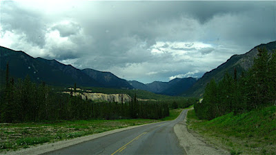
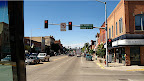
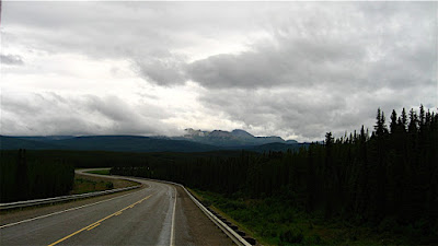
Road from Liard to Teslin

Soon after we left Liard Hot Springs, we saw a large herd of bison grazing along the highway - 
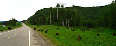
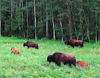
mostly cows and calves. We had seen "watch for bison" signs, and they weren't kidding! Luckily, the highway is straight and has wide shoulders for better wildlife visibility, and there is not much traffic, so it is easy to avoid collisions. It would be very intimidating to ride through a herd of Bison on a motorcycle, though, not to mention a bicycle!

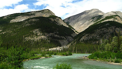
Today it rained most of the way, but as the sun came out, the scenery got better, and it's quite beautiful here. This stretch of the Alaska Highway plays keep-away between the British Columbia and Yukon border, crossing back and forth several times before finally deciding to move into the Yukon.


Along the way, we began to see mystery tracks along the side of the road. At least Devin thought they were tracks - I was pretty sure they had been made by something mechanical for the highway, since they were so regular, there was a set on each side of the road, and they went on and on for miles. I just about had him agreeing with me, when we caught up with the makers of the mystery tracks - two HUGE Bison bulls, one on each side of the road, 
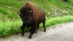
walking north. The mystery deepens! The cows and calves were miles back - why were these two solo bulls walking north on the highway, on opposite sides of the road yet together, away from the herd? Were they outcasts? They were both so huge and healthy looking, it is hard to imaging they had lost a dominance challenge - maybe the females just didn't want them around...?

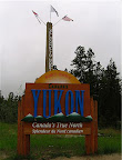
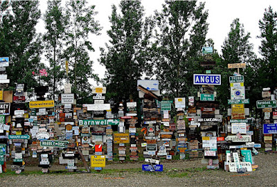
Finally we got to the official border crossing and stopped to take our obligatory photo of the sign - "Welcome to North of 60" and "Yukon, Canada's True North." Shortly after the border we came to Watson Lake and many more signs- tens of thousands more - the famous Watson Lake Signpost Forest! According to the website Explore North,
One of the most famous of the landmarks along the Alaska Highway was started by a homesick GI in 1942... and you can even add your own sign to the over [60,000] already there!

In 1942, a simple signpost pointing out the distances to various points along the tote road being built was damaged by a bulldozer. Private Carl K. Lindley, serving with the 341st Engineers, was ordered to repair the sign, and decided to personalize the job by adding a sign pointing to his home town, Danville, Illinois. Several other people added directions to their home towns, and the idea has been snowballing ever since.

What a crazy place. We didn't stop or add our own sign, but did drive around the block and took photos of the tens of thousands of signs taking up a couple of acres of land.


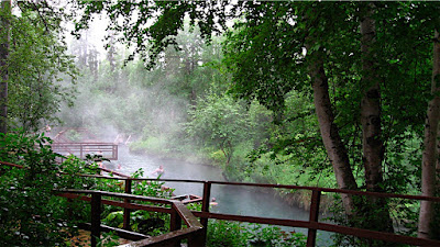
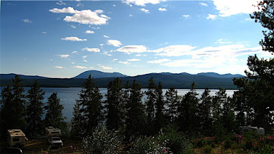
Further up the highway, we checked out Dawson Peaks RV Park as a potential place to camp - it was very nice, in a forest on a lake, and we read in The Milepost that it was featured in the Sue Henry Alaska Mystery,"Dead North" which sounded interesting, but something told us to keep going that day.

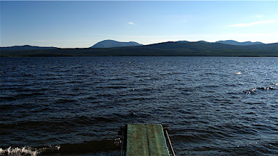
We ended up at the famous Mukluk Annie's, where everything is FREE, FREE, FREE!
  • Free camping on Teslin Lake
  • Free dump and fill
  • Free boat ride with dinner
  • Free RV wash with dinner
  • Salmon Bake (not free, but a great deal by itself!)

What a deal! The free campsites are really nice, overlooking Teslin Lake - we needed water and to dump our tanks, so that was great, too. 
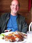
We were hungry and went to dinner - omg. HUGE portions! Quite good, too - salad bar with green salad and fixin's, potato salad, pasta salad, rolls, baked beans and baked potato, then a huge plate of salmon and/or ribs, grilled right there, coffee and/or tea to drink, and even dessert!

The only problem was I fell asleep after such a huge meal and missed the free boat ride. It was supposed to leave at 8pm, and I got there probably a minute or two after and the boat was already pretty far out, so I think they left early. So sad, standing at the dock alone... I guess I'll try to collect on the way back, if they are still open.

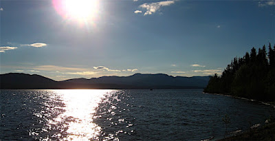
Teslin and Teslin Lake seem to be big Tlingit areas - with museums and stores offering Tlingit goods. We crossed the continental divide again today - up here the water on the west drains to the Bering Sea/Pacific via the Klondike River, and the waters to the east drain into the MacKenzie and into the Arctic Ocean up by Inuvik. The native people on this (west) side of the divide had Pacific salmon runs and a plentiful, regular food supply, so tended to be more settled in villages, where the ones in the Arctic watershed generally did not have a reliable food supply in one place, so followed the Caribou herds and were more nomadic. A very clear example of how environment affects culture.

I talked to some bicyclists in front of the restaurant who were riding the Alaska Highway south, and I was thinking how intimidating it would be to have to ride between those Bison bulls on a bike! The woman was from Quebec and had monster thighs - she's obviously been doing this a while. She is riding to South America! The man was from Germany, and they were just riding together for a while for safety - they had just seen a bear crossing the road earlier today.

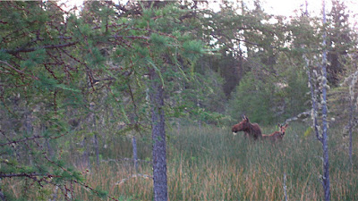
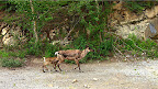
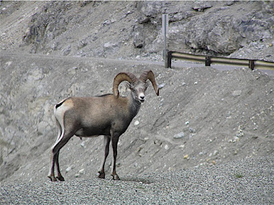
Today, in addition to the bison, we also saw Harriers, Golden Eagles, deer, and two black bears - one dead and one alive. The lake here has swallows - barn swallows and rough-winged(?) and terns and gulls. I'm sure there are ospreys and bald eagles, too. We passed through lots of moose country, but didn't see any today. We also passed through a Caribou Herd area, but didn't see them, either. Still, a herd of bison, two huge lone bison bulls, a golden eagle, 3 harriers, a deer and 2 bears is pretty darn good for one day's drive!

Sunday, July 22, 2007

Liard Hot Springs

Liard (rhymes with "weird") River Hot Springs Provincial Park was quite wonderful. The public campgrounds in Canada are all so nice and well-maintained. This one was quite full and we were lucky to find a campsite, but we found a nice private site with trees all around. This area is very lush with vegetation. After driving all day, Devin is usually pretty tired, but I wanted to take a look around, so I took a radio and walked over to check out the hot springs. They were much farther in than I expected - maybe almost a mile into the forest on a boardwalk path. It first crosses a large fen, then enters the forest. I felt a bit like Dorothy on the yellow brick road - expecting to encounter the tin woodsman around any corner!


When I finally got to the lower pool, I was surprised to find several people there since I hadn't seen anyone on the way in. I foolishly did not wear or bring my swimsuit, since this was supposed to be just a short scouting mission! So I continued a bit further, checking out the "Hanging Gardens" before it started to rain in earnest.

The "Hanging Gardens" were dry, but the gardens along the boardwalk all the way to the end were lovely - I noticed 2 kinds of orchids (the white Ladies Tresses, and the green Rein Orchid), white Anemones, yellow bush Potentilla, wild Rose, Baneberry, False Solomon's Seal, wild Raspberry, Horsetail, Rushes, yellow Monkeyflowers, Fireweed, and some blue flowers - I thought they were a kind of flax, but I think they were something else, and more I can't remember.

I decided to head back as it was starting to rain harder, but in the shade of the large trees I was staying dry... along with several dozen mosquitoes who had the same idea, apparently! After a while, getting wet didn't seem like such a bad idea, as it wasn't all that cold, so I started down. I stopped at the lower pool and sheltered in the dressing room, but started feeling sort of creepy being in there with no good reason. I sure wished I had a swim-suit, since the pool looked so inviting and steamy in the rain. It was definitely not a "swimsuit optional" vibe, though, so I walked back in the rain.

When I got back I was able to take a hot shower in the RV and crawl into bed all warm and toasty.

The next morning we discovered that the towel over the Jeep window may not have been a great idea. Since I had attached it by hanging the ends inside the removable "Freedom Hard Top" (front of the roof), and since it had rained on it, it was all wet and had wicked water into the Jeep - it was humid and a bit mildewy smelling in there - ewwww. So we left the windows down and put the towel on the roof to dry and decided we'd just risk rocks hitting the windshield.

We decided to stay another night here so Devin and I could go back up to the hot springs and soak. Devin took his Segway, which was great on the boardwalk. We walked all the way to the upper springs, but the Alpha (lower) pool is much nicer than the Beta (upper) pool. Though beautiful, the upper pool is 3 meters deep (over 9 feet) and mucky on the bottom. It's like very warm bathwater - you can swim in it. But there are no benches, just stairs going in, so it just wasn't as inviting for us. Both are natural, minimally developed (not cement pools, just added decks and benches). The lower pool had a nice gravel bottom, a waterfall between pools that you can sit under while it massages your shoulders and back with warm water, underwater benches out in the middle and at the edges, a deck with stairs into the pool at various points, changing rooms, benches, and composting toilets set away from the water. What a beautiful setting!

After a nice long soak, we had a pleasant walk back as it started to rain lightly again. We saw a moose cow and calf in the fen area on the way back! A perfect ending to another wonderful day.

Alaska Highway, Fort Nelson to Liard Hot Springs

Today's drive was spectacular! Quite a contrast from day 1 on the Alaska Highway (yesterday), we passed through some of the most spectacular scenery and wildlife sightings of the whole road today.

Stone Mountain Provincial Park took us up into the Rockies again, over Summit Pass, the highest point on the Alaskan Highway, and wildlife was abundant. We saw many Caribou with calves and Stone Sheep, a kind of bighorn sheep. Technically, the stone sheep are "small horn" sheep, but I couldn't have told you the difference by horn size. They were a darker color than our Mojave and Sierra Bighorn back in California, though. And not at all shy!


The weather was beautiful - stormy with little spates of rain toward the end of the day. Nice cloudscapes. The road took us along beautiful rivers and through gorgeous mountains - this is definitely an area that would be worth a trip to explore all on its own.

There is camping in Stone Mountain and also along the beautifully surreal turquoise waters of Muncho Lake, where we saw even more Stone Sheep clinging to the cliffs along the road, Caribou and calves, and even Bison! The Highway around Muncho Lake is quite a feat of engineering - we read that they lowered men on ropes to place explosives underwater to make the road cut in the cliff. It's one of those places where you almost feel guilty for driving at the same time you are glad the road is there so you can see it.

Devin said, "it's nice to be away from the hustle and bustle of places like... Montana" ha. But that's the way you feel as you get farther and farther north - fewer and fewer cars are on the road, more wildlife, and more a feeling of the freedom of the open road. Adventure is always just around the corner!

We drove to Liard Hot Springs, where we camped for two nights. Liard rhymes with "weird," by the way. We got into camp early enough that I went on a little scouting walk to the hot springs - fantastic! More about that next post.

See more photos of today's adventure

See more photos of Stone Sheep

Friday, July 13, 2007

Glacier National Park

Enjoy our "Going to the Sun" Slideshow:


After getting our alignment done this morning, we spent the rest of the day enjoying the scenery! We drove through Glacier on the "Going to the Sun Highway" - beautiful! It is a narrow, winding, mountain drive that hangs on the edges of cliffs, goes under and over waterfalls, up above timberline at Logan Pass, and is generally gorgeous. Highlights were seeing Mountain Goats - even if they were right in the road, surrounded by tourists, licking water off the road (instead of drinking from pure mountain streams nearby - I guess they liked the saltiness? The "Weeping Wall" where we drove under misting waterfalls with the top off the Jeep and I got a little shower, views of Bird Woman Falls and numerous others, beautiful mountains, and , yes, even some glaciers. We also enjoyed the area behind the visitor center at Logan Summit - meadows full of Glacier Lilies, snowfields, and scanning for wildlife.

I mentioned previously how Devin stayed in a cabin in Glacier years ago, and read "Night of the Grizzlies," which happened right in the area where he stayed. I read it, too, so I could share in that memory with him, and we drove by Lake MacDonald on our way out and looked at the cabins in "Kelly's Camp" area where he stayed. Though we kept our eyes out, we didn't see any grizzlies today, though.

The weather was VERY warm - it was 100 degrees in Kalispell, and not all that much cooler in Glacier - no wonder the glaciers are melting at such a rapid rate! Glacier is still a beautiful National Park, though it will be sad to see its namesake glaciers all retreat into tiny snowfields as world temperatures rise. In places like this, as well as above the Arctic Circle, Global Warming is a very real and very serious threat. Here it is to scenery and the local ecosystem, but other places it is to people's very way of life and even ability to live there. No one in Alaska is arguing about global warming - they see it up close and personal. But more on that later...

After our long day's drive (and yes, we are contributing to carbon emissions that contribute to global warming by doing so, as is everyone who drives - we have bought carbon offsets through TerraPass, however, and we hope that helps), we returned to Kalispell by way of Whitefish and the UPS store, where we picked up packages in the nick of time - we walked in just as they were about to close! Now we are ready to head north.

Back to Kalispell to get ready to head to Canada tomorrow!!

Kalispell - Legacy Timber Town

Saw a sign in a store window that said "We Support the Timber Industry" and it reminded me of Humboldt County, where I went to college. It made me sad, because it reminded me of the divisiveness and polarization of that community around forest management issues. Politicians like to reduce complex issues into simplistic sound bites and talking points, like "jobs vs. owls" which is SO untrue - but gets people elected as folks fear for their livelihoods. Logging is an old and time-honored profession, and I hope there is still logging hundreds of years from now - because of course, that'll mean there's still forests big enough to log. Sustainability isn't just for forest ecosystems, wildlife, fisheries, watershed, and recreation, but also for the economy and jobs. If loggers want to retire and have the next generation also able to retire doing what they love doing, we can't cut down the last remaining forests!

Kalispell is a "legacy" timber town, because although the timber industry still seems important here, there is a large amount of growth and new construction, shopping malls, and suburbs sprawling out from the town's center, which is also beginning to see renewed growth.

It's a beautiful area, obviously undergoing some difficult changes in economy, but I see lots of hope there for it to become a really wonderful place to live and enjoy.

Wednesday, July 04, 2007

Beartooth Highway

What better way to celebrate our country's birthday than to visit its first National Park? The National Park idea and system is something that makes me very proud of my country! Today, we went on a drive through the northwestern part of Yellowstone and out over the Beartooth Highway, the longest stretch of alpine highway in the lower 48 which Charles Kurault called "America's most beautiful highway," through Red Lodge, Montana, and back through Livingston to our Yellowstone River campsite. What a fantastic day!

We crossed the Blacktail Plateau in Yellowstone, and the Petrified Tree near Roosevelt, and on through the Lamar Valley. There, we saw a huge herd of Bison, which was crossing the road, grazing alongside the road, rolling in the dirt, and generally enjoying life in the Park. We also saw Pronghorn, a little too far away to photograph. Click here to watch a little video from our pocket camera of the Bison.

Coming through the Lamar Valley, we enjoyed spectacular scenery, a few geysers like Soda Butte, lovely brilliant green meadows, and rugged mountains. The road exits the park through Cooke City, Wyoming, and continues on through more gorgeous scenery to climb toward Beartooth Pass. Pilot and Index Peaks were a spectacular sight near Cooke City, which you could also see from up on Beartooth Pass.

Once we left Yellowstone, we began the official Beartooth Highway Scenic Byway, and the scenery kept getting even better as we climbed higher and higher. We stopped at Beartooth Lake, at the top of one grade, which was spectacular. The lake comes up so suddenly we almost crashed the car in our awestruck surprise! Okay, I exaggerate, but it was quite beautiful and too sudden to get a photo of that first view from the road. We pulled into the campground by the lake, which was nice, got some photos of the lake from the boat launch area, and we saw a moose in a meadow. The views were very nice as we climbed, but there was so much more! According to the Scenic Byway website, "The Beartooth area is one of the highest and most rugged areas in the lower 48 states, with 20 peaks reaching over 12,000 feet in elevation. Glaciers grace the north flank of nearly every towering mountain peak." This statement is no exaggeration!

We began to see snowfields and the vegetation changed to tundra. Wildflowers were filling the alpine meadows and flowers I've only seen when I've climbed high mountain peaks were lining the road! Sky Pilots are a beautiful purplish blue flower that are unusual for tundra species because they grow taller than the usual mats and "belly flowers," and I always get excited to see even one or two of these alpine beauties, so you can imagine my delight to see them as roadside bouquets. Beautiful little glacial tarns - small lakes - dotted the hillsides along the road. And we kept going up!! We kept thinking it must be the pass, but no, the road seemed to go over the top of the mountain instead of a pass. What looked like a natural pass had vertical cliffs going down the other side for thousands of feet - oh, okay, so that's why the road keeps going up! It's amazing a road was built here at all, and for those who can't hike up to the alpine life zone, this road offers a rare opportunity to enjoy life at these great heights. It really made us excited to get to the Arctic Tundra we hoped to visit on our trip, in Yukon/NWT and Alaska!

Finally we got to the pass - there are two summits to the pass, and we went to the west summit. There were dark clouds threatening an afternoon thundershower and some early fireworks, but we enjoyed the view for quite a while. We met some guys on motorcycles who were just as excited about the tundra as we were, and who knew about the Dempster and Dalton Highways (one was from Canada) and told us how much we'd love them, and that in August it will be autumn on the tundra and is just like New England with lovely fall colors, only a foot tall! We can't wait.

After the pass, the road descended a winding steep grade into a steep, avalanche prone canyon with a viewpoint looking back up toward the pass and down the canyon. There was a campground at the bottom that looked really nice for future reference.

The road then led out of the mountains through Red Lodge, which we hit at sunset - a great little town, home of Crazy Creek Chairs (we like ours!), with flags lining the charming main street. We cut over to the main highway through fields of wheat and hay in the rolling hills, and headed home. This was the part of the road where the bugs were so bad that we ran out of window washing fluid - we were running it constantly just to be able to see. We had to pull over at a rest stop and use Windex, which we happened to have in the car. A family in a minivan saw me doing that and asked if they could use some - it was bad out there! A few minutes later, it didn't even matter. We bought a gallon of windshield fluid when we got into Livingston before continuing back to the RV Park. Happy Independence Day bugs! Be free of our windshield!

Along the highway, we saw lots more fireworks - it seemed every little ranch and small hamlet along the way had huge fireworks going off!! What a fourth of July!! Enjoy the slideshow of the day below: