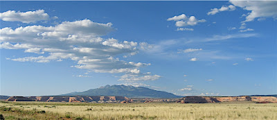
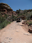
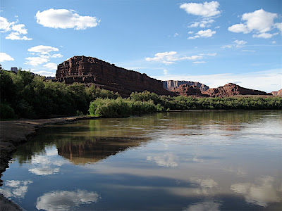
Gemini Bridges (or "Jiminy Britches" as Devin called them ;-)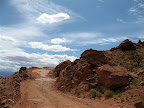 This Jeep trail starts north of Moab just south of the turnoff for Canyonlands. It starts out going along a ledge on the side of a cliff, offering nice views of the surrounding countryside. Moab area certainly is beautiful, and quite varied, with different types of sandstone/limestone formations, cliffs, mesas, spires, hoodoos, and the La Sal Mountains towering in the distance, their cool
 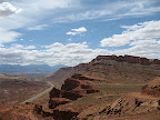 green slopes and snowy caps contrasting with the reds, yellows and creams of the desert below - add to this the Colorado and Green Rivers, with their corridors of shimmering green Cottonwoods meandering through the redrock desert. Again, Utah lives up to its reputation as a "promised land" - in natural beauty, anyway.
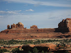
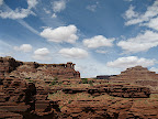
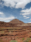
The valley on the other side of the "entry cliff" was lovely, and had a cool rock formation called "Goonie Bird Rock" near the end, when we climbed up another mesa and continued along the top. One thing I really like about this type of landscape is the changes between valley, cliff/canyon, and mesa top. It is l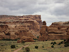 ike three different worlds, all around one mesa. The mesa top gives a feeling of wide open spaces, like the prairie, with long views, while the valleys are more homey, wide, yet enclosed by encircling cliffs, while the canyons and cliffs are wild, with views and close ups of rock formations, sometimes narrow and dark, sometimes with rivers or creeks along the bottom and surprising oases of cottonwoods at hidden springs - secret worlds in which you never know what to expect around the next turn.
On the top of this mesa was a side road that led to a trail we wouldn't be taking today - "Metal Masher"! Lots of Moab Jeep trails which are designed for folks wanting to test the limits of their machines have names like "Cliffhanger," "Widowmaker," "Metal Masher" and the like. We avoided those trails, as we were more interested in getting to scenic spots than trying to see if we could tip the Jeep over. To each his own!
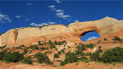
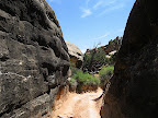
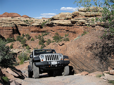
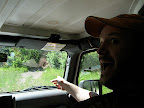
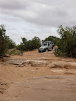 When we got out to the Gemini Bridges turnoff, most people were parking and walking out, so Devin parked and I started walking, carrying a radio. When I realized it would be too far for Devin to walk, and also when I saw the route painted on the slickrock (a white dotted line marked the trail), I radioed him and told him he could make it and drive out. I walked, and helped him scout the route, and it was again no problem for Devin and the Jeep. We could drive right up to the Gemini Bridges viewing area, close enough for Devin to walk right out to the edge!
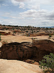
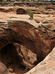
 Apparently, that wasn't close enough for some people, because I found a plaque dedicated to Beau James Daley, who died there. I later Googled him, and he had driven off of one of the bridges trying to drive his Jeep across it. I was nervous enough just walking across! We were at the level of the tops of the bridges, and it was a long way down to the bottom. What an awful thing.
 A young family walked out at the same time as we did, and the woman was so terribly acrophobic, she couldn't stand to see her husband and son sitting on one of the bridges, far from the edge, and being quite safe. Poor thing was practically in tears, and her husband and son were so patient with her. It reminded me of my mom and dad - my mom was always cringing and saying "Ge-eene!" when we drove on roads with drop offs and got too close to the edge at viewpoints. Somehow I managed not to pick up the irrational part of that fear, but I am very rationally nervous about getting too close the the edge when the edge is sloped, or gravelly, like it was in places near the Bridges.
While we were there, a group of kids on mountain bikes came riding up - they were all pre-teen boys, and I was SO grateful when one of their chaperones made them get off their bikes and didn't let them ride out onto the bridges!! Of course, they wanted to, boys that age being little daredevils with absolutely no sense of their own mortality. I didn't want to see a horrible accident! This viewpoint was busier than I would have expected, especially for a Thursday, but it is a popular place, and we saw more Jeeps, and highly modified ones, in Moab than anywhere else we've been.
 I met a couple out there who we had passed on the road on the way out, who turned out to be a brother and sister from near Park City: Cynthia and Kent Dinsdale. They were great - she was a retired teacher and he was a retired school bus driver, bless their hearts!! After my year of teaching middle school, I bow down before teachers who go the distance - she went over 30 years!! We got into teacher talk and she understood everything I talked about immediately, and had experienced much of it herself. Not that encouraging to think about getting back into the classroom when a 30+ year veteran had the same misgivings about the profession. People really have NO idea how hard teachers work, and how hard their jobs are. People talk about summer vacation, but that is necessary recovery time for a punishing workload the rest of the year. Anyway, boy did we talk! Funny to get into that sort of animated conversation out in the middle of nowhere off 4WD roads at some natural bridges in the Utah desert, but we definitely connected. They were both really nice and I wish I'd gotten more information from them - she said she had a blog, and I thought I'd be able to find it, but I haven't.
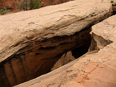
It was difficult to get a photo showing the two bridges, since they were so close together, but I tried from a few different angles.
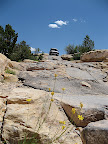
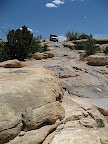
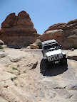
On the way back out, some people took a picture of us in the Jeep as we crawled up the rocks back to the main road - I guess we may be in someone else's blog now - ha.
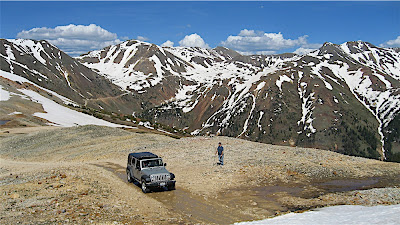
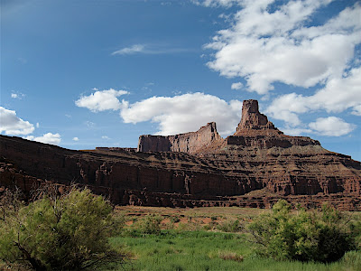
Shafer TrailNext we drove out through Canyonlands National Park to the Shafer Trail, which leads down the cliff face in a series of many steep switchbacks to the White Rim Trail. I kept wondering why this road was built, and it turns out it was for a uranium mining haul road. It's hard to imagine that it would be easier to haul ore up to the top than down along the river, but I guess it was. Before it was a haul road, it was a cattle trail - Mr. Shafer wintered his herd in the basin below and drove them to the mesa top for the summer. I suppose the pre-existing cattle trail made it easier to create a road. The top part along the rim and going down the switchbacks was spectacular, and it only got better and better. This is some of the most beautiful country on Earth! I actually asked Devin if he could drive closer to the edge going down the switchbacks, so I could shoot down - that's how steep it was - and how scenic.

 When we reached the bottom of the cliff, we were on the level of the White Rim trail, which follows a rim of white sandstone around for miles and miles. We had hoped to do a multi-day trip on the White Rim trail in the Jeep, but it was a bit hot for that, and also you couldn't complete the loop as there was a slide near the end. We had seen the White Rim trail from Grandview Point in Canyonlands the last time we were here, and now we have to come back again to do the whole trail.
 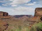 And again and again and again to explore this incredible area deeper and deeper. There are so many neat "backcountry" campsites maintained by the BLM in the area, it would be wonderful to someday just go out and stay out for longer periods. But today was not that day, and we turned off of the White Rim trail and took the Potash Road back toward Moab instead.
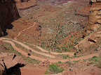
 Immediately the road dropped below the white rim and the landscape changed again. Rocks that looked like crops of white capped mushrooms rose up from the valley floor and canyon walls. A Campground was near the junction, with no one in it. We continued down an arroyo until the canyon walls rose higher and we found ourselves overlooking the Colorado River, in a huge gooseneck far below. We saw kayaks far away on an island in the river, and saw a jetboat turning around near there.
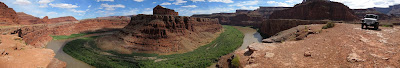
 At the gooseneck overlook, we met Ray, who was very friendly and very happy to be discovering the desert and life in an RV - he had a 4WD truck camper and was recently retired form Denver. We got the feeling that exploring this country had given him a new lease on life. We told him about Baja California, gave him a whole bunch of useful links and told him about some other desert places to explore and he ate up this information. It's nice to be on the giving end of advice and information when we've learned so much from others to prepare for and plan this trip!
After we left the river, the scenery changed again and widened so much I got the theme from "Big Valley" going through my head! It was just
classic western scenery, and I half expected to see circling wagons, attacking Comanches, and John Wayne riding up. I guess this was Butch Cassidy / Hole in the Wall Gang territory. At least back in Capitol Reef, there was a "Cassidy Arch" and more than a few formations out here are named for them.
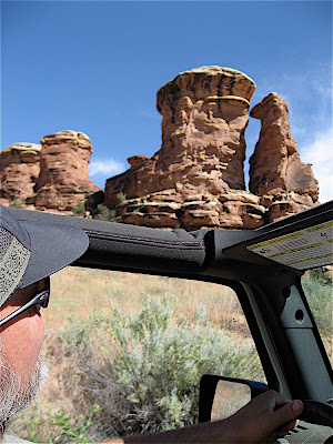
 Some of my favorite formations were a perfect square pyramid with a lone Juniper on top, a mesa that was a curved amphitheater, various pinnacles and spires, and a rock that looked like the Mount Rushmore of funny cartoon old men!
"Thelma and Louise Point" is out there somewhere - pretty near to where we were, but we didn't drive out there. Another reason to go back.
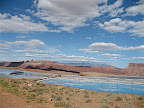 Soon we came to Potash, and the evaporating ponds where potassium salts are dried. "Moab Salt, LLC" is one of the largest employers in Moab, and one of the main sources of potassium in the country. The evaporating ponds were bright blue, perfect reflections of the bright blue sky, and looked unearthly against the backdrop of redrock mesas and the La Sal Mountains.
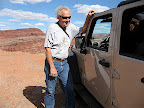
We hit pavement soon after, and then the Colorado River. Moab Salt maintains a river put-in open to the public on their river access, and we drove the Jeep down to wet its tires - ha. The road followed the river all the way back to Moab, with the  afternoon light putting a magical glow on the cliffs, petrogylphs, arches and climbers, this little byway was much more scenic in itself than we had expected and we would recommend anyone drive out that way as a worthy side trip. Of course, for anyone with a 4WD vehicle, we'd recommend the entire Gemini Bridges/Canyonlands/Shafer Trail/Potash Road loop we took today, as it was incredibly scenic and varied!

Another day in Paradise!
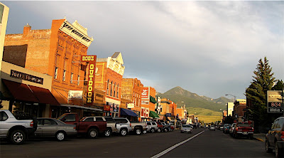
 Josh, of course, gave us the Grand Tour of Livingston - he is so proud of his little town and loves to show it off in all its western classic glory. It IS a great place, with just enough culture to be really interesting, but not enough to make it snooty. It's a real place, a railroad town with the railroad still the centerpiece. But also with some
  great restaurants, cafes, shops, and theatre, downtown right alongside the Montana classics like The Stockman and Bob's Outdoor sporting goods. The light was especially good because of a fire in Yellowstone making the sky a little smoky, and giving everything a beautiful glow in the late afternoon light. Lest everyone think of moving there after seeing the pictures and hearing about the town, it does get cold there in the winter!
 After we were settled in, we went on a drive in the Jeep - Josh took us up to the Bridger Mountains over Flathead Pass, and we explored almost every side dirt road that led up the mountains on either side of the road. Josh was funny, getting all excited every time we saw another road that looked promising! We found a few really nice little side roads that led up to meadows or views, and some "interesting" dead ends where we all got
  out to help Devin get the Jeep turned around safely. At one place, an open mountainside meadow with a view of the surrounding countryside, Josh tried to fly a kite, "tried" being the operative word there - ha. There were so many deer flies or meat bees Devin and I stayed in the Jeep to watch, laughing hysterically at ourselves sitting inside watching Josh and his pitiful little plastic kite fight the bugs between small gusts of light breeze - ha. The bugs weren't as bad at all on the other side of the pass, where we found a great road that led up to a fantastic view in the other direction and had a tailgate picnic lunch.
 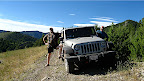 Then we went across a little creek where we had to stop and wait for a deer who was getting a drink. Devin and Josh had a laugh coming back on that trail, as they went up the steep side of the trail that I wouldn't "let" them go down - ha. Lots of beautiful scenery and a little Jeep adventure and of course good company - it was a fun day!
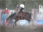 We did, however, make it to see the Livingston Roundup Rodeo! Devin had never been to a rodeo before!! The rodeo has been a 4th of July tradition in Livingston for something like 75 years. Nothing like going to a big rodeo in a small Montana town to celebrate the 4th! It was one of those all American experiences that take you back to younger days and simpler times. We got tickets for July 3rd, or rather, Josh got us tickets, which was great. The clown was also really funny and sort of like the emcee for the rodeo. For a small town, Livingston puts on a pretty great rodeo, but even more than the calf roping, trick riding, barrel racing,
 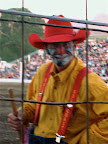 bronc and bull riding, their fireworks display eclipses every other fireworks show either of us has EVER seen! The Pasadena Rose Bowl bills its display as the largest in Southern California, but the one in Livingston was MUCH bigger and better. It just kept going on and on and on... spectacular! We enjoyed it quite a bit! Since it was dusk and we were sitting behind a fence, our photos didn't turn out all that great, but you can still get the feel for the excitement - we were so close that we had to watch out for dirt clods getting thrown from hooves of bucking broncs and kicking bulls! Click play on the slideshow below to see more bronc bustin' action: